23 February 2011

Oakland Marathon neighborhood tour - # 14 - Jack London Square

15 years ago it would have been a stretch to call the Jack London Square area a neighborhood.  But in that time, many of the old warehouses that predominated have been converted to lofts and condos, and many new residential structures have been erected.

The center of the Jack London Square area is where Broadway ends at the Embarcadero.

The elements of the area are disparate.  What you have in addition to the increasing number of large residential buildings are:
- the Jack London Square commercial and touristic area
- the Oakland Produce Market which comes alive in the early morning hours
- the entertainment venues including Yoshi's jazz club (formerly in Rockridge) and the multiplex movie theatre
- remaining light industrial and distribution enterprises
- all manner of places to eat and drink
- Oakland's Amtrak station
- Oakland dock for the ferry that runs between Oakland, Alameda, and San Francisco

What will be interesting to see in coming years is whether the newly built Jack London Market is successful.  This colossal development at the east end of Jack London Square and across from the train station, aims to replicate the success of San Francisco's Ferry Building as an artisan food marketplace in the East Bay.  An article from July 2010 in the East Bay Express describes the challenges ahead.


Solid brick buildings like the American Bag Co. at right were the norm in the area surrounding Jack London Square.  There are still many of them, though most of the large ones have been renovated for reuse as offices, lofts, or condos.


But across the street from the old building is this very new condominium.  Its style is a take on an early 20th century warehouse but there is no mistaking its modernity.


The streets look quiet in these three pictures taken around 3:00 p.m., but come back around 5:00 a.m. and it will look a lot different.  This is the Oakland Produce Market.  Once in the early 90s I took a day off just to see what happened in the early morning hours here.  If you go there at an early hour, my advice is to watch out for the guys driving forklifts - this is their turf!


Note the tall building -"The Ellington" -in the background - another new condomimium.


Historic dive bar: Heinold's First and Last Chance.  Jack London was here.


Oakland's Amtrak station.  Trains run in the street for about 4 blocks along the Embarcadero directly in front of Jack London Square.  This is also the Union Pacific (formerly Southern Pacific) mainline track leading north, south, and to the Port of Oakland.  There is a lot of coming and going by rail in this part of Oakland.


Why I love Oakland.  Come on, how many places can you find a vegan soul food restaurant?  (Solely Vegan - at the corner of Broadway and 2nd.)


On the same block of Third Street as Solely Vegan lies the old Western Pacific train station.  When the original (pre-Amtrak) California Zephyr ceased operation in March 1970, the train station was no longer needed.  It has had many uses since then.  Up until not so many years ago, the mainline track (for freight) of the Western Pacific Railroad ran down the middle of Third Street on its way to the port.  Eventually (late 90s?) the Union Pacific, acquirer of both the Western Pacific and Southern Pacific stopped using the old W.P. line in Oakland, and the track was removed from Third Street.  Trains now operate exclusively on the Embarcadero.

Beer Revolution is located in the modest building with the blue canopies just to the right of the old station.  It's agit-prop Che Guevara meets craft brew.


What the cool kids are drinking.  This is the home of Blue Bottle Coffee, the ne plus ultra of Bay Area coffee.  I was interested to see that besides a few other retail locations in the Bay Area, they have a roastery in Brooklyn, NY.


Oakland Marathon neighborhood tour - navigational links:
Backward to: Chinatown
Forward to: West Oakland
Index
Introduction
Oakland Marathon website

19 February 2011

Oakland Marathon neighborhood tour - # 13 - Chinatown

The course of the marathon kind of sideswipes Chinatown in its southwest corner, but it really doesn't go through Chinatown.  (The half marathon on the other hand really does.  Take a look at the map of the half if you like.)

But since I'm fond of Oakland's no-nonsense Chinatown, it's part of the tour.

If you run the marathon you won't see any of scenes in the photographs to follow but you'll be very close, and you should come back another time to take a closer look.  Bring your appetite as there are restaurants galore.


I think of the heart of Chinatown as Broadway on the west to Alice Street on the east, bounded by 11th Street to the north and 7th Street to the south.


A typical market with produce both outside and in.  Prices are remarkably low.


The Legendary Palace Restaurant.


Chinese video store window, with political sign.


As in other west coast Chinatowns, there is a significant presence now of Vietnamese.


Oakland Marathon neighborhood tour - navigational links:
Backward to: Fruitvale
Forward to: Jack London Square
Index
Introduction
Oakland Marathon website

16 February 2011

Oakland Marathon neighborhood tour - # 12 - Fruitvale

From the Dimond District runners continue on a downhill trajectory into the Fruitvale neighborhood.


If you don't have time to make a visit to Mexico or Central America, consider an afternoon in Fruitvale instead.  The neighborhood is predominantly Latino but if you are thinking exclusively of Mexico you should also include El Salvador, Guatemala, Nicaragua, and other countries.


The primary business district - but by no means the only one - is along International Boulevard and Fruitvale Avenue.

BART's Fruitvale station lies just west of International Boulevard and includes a transit village consisting of housing and businesses.  A walk along International Boulevard is filled with sights, sounds, and tastes of Latin America.


A Salvadoran restaurant


Los Mexicanos Bakery


Mariscos La Costa (The Coast Seafood Restaurant)


Dulceria La Rosa - Mexican party store


Beautiful St. Elizabeth's Catholic church on 34th Avenue


Oakland Marathon neighborhood tour - navigational links:
Backward to: Dimond District
Forward to: Chinatown
Index
Introduction
Oakland Marathon website

13 February 2011

Oakland Marathon neighborhood tour - # 11 - Dimond District

Next stop on the tour is the Dimond District.  No, that's not a typo that should read "diamond", although that's how it is pronounced.

The race skirts just east of the main business district of Dimond.


Looking northeastward and uphill on Lincoln at the intersection with Macarthur Blvd
This is where the race comes rocketing downhill into Dimond from the Mormon Temple.


Fruitvale Avenue is the "Main Street" and business artery of the Dimond District.  As with almost any part of Oakland, you'll find a wide variety of eating opportunities here.


Just north of the Dimond business area is a lovely park, Dimond Park, which straddles Sausal Creek, and separates the Dimond District from the Glenview District.  The Glenview area is not traversed by the marathon, but its small business area on Park Boulevard is very attractive.


Oakland Marathon neighborhood tour - navigational links:
Backward to: Mormon Temple
Forward to: Fruitvale
Index
Introduction
Oakland Marathon website

11 February 2011

Oakland Marathon neighboorhood tour - # 10 - Mormon Temple

It's not exactly a neighborhood, although a small business area is located on the other side of Hwy. 13 where Joaquin Miller Road and Mountain Avenue meet, but Oakland's Mormon Temple is worthy of mention as a landmark that marathoners will see at the 10 mile point in their endeavor.


The temple is easily visible from much of Oakland, and its Emerald City-like appearance is all the more so at night, when it's brightly lighted.


When the Mormon Temple is in sight, runners will be able to breathe a sigh of relief.  At this point in the race,  the serious uphill stretches are over.

What follows is a steep descent down Lincoln Avenue to the Dimond District ultimately leading to the Fruitvale area.


Oakland Marathon neighborhood tour - navigational links:
Backward to: Montclair
Forward to: Dimond District
Index

Introduction
Oakland Marathon website

07 February 2011

Oakland Marathon neighborhood tour - # 9 - Montclair

Ask any Oaklander where the rich people live in Oakland, and you'll hear "Montclair".

"Piedmont" doesn't count as an answer because it's a separately incorporated city, that leads a San Marino-like existence surrounded entirely by Oakland.

And for that matter, where Oakland ends and Piedmont starts is impossible to determine by the looks of the neighborhoods, because the areas of Oakland that border Piedmont are just as swanky.

Montclair is the area of the Oakland hills that lies on both sides of Hwy. 13 that runs between I-580 to the south to a junction with Hwy. 24 to the north, close to the Caldecott Tunnel, which then leads east through the hills and over to area code 925 (Orinda, Lafayette, Moraga, Walnut Creek, etc.) also known as Contra Costa County.

In essence, Montclair is a little valley between one low range of hills that belongs to both Oakland and Piedmont, and the higher range of the Oakland hills that separates Alameda County and Contra Costa County.  Parts of Montclair are downright bucolic.

In the 90s I had the pleasure of living on the lower side of Montclair very close to Piedmont (Harbord Avenue) and later on Skyline.  The backyard of the house I shared on Skyline with my friend Larry, who owned the house, backed up to the trails of Redwood Park.

With all due respect to the trails of upper Bidwell Park in Chico where I live now, I prefer running the trails of the Oakland and Berkeley hills.  They're shaded in many spots with redwoods. oaks, and eucalyptus, and the surface is mostly soft duff, compared with the hard lava of upper park.

Montclair itself might as well be Mill Valley.  The business district is called Montclair Village, and is centered on Mountain Avenue and La Salle Avenue, although a much smaller business district also exists on Thornhill Avenue just east of Hwy. 13.  The feel is Mediterranean and wealthy.


A pretty "back door" to Moraga in Contra Costa County is to go up to Skyline Boulevard, and then take Pinehurst Road through the hamlet of Canyon and on to Moraga.  Other than the fact that the railroad went through a nearly mile long tunnel in the Oakland hills, this route largely traces the route of the Sacramento Northern Railway.


THESE CONCRETE ABUTMENTS ON MOUNTAIN AVENUE ONCE SUPPORTED A RAILROAD BRIDGE.  THE RAILROAD CEASED TO OPERATE IN 1958.  A TRAIL RUNS EAST (LEFT IN THIS PICTURE) FROM MONTCLAIR VILLAGE TO SHEPHERD CANYON ROAD, CLOSE TO THE LOCATION WHERE THE WEST PORTAL OF THE TUNNEL ONCE WAS.

For marathon runners, Miles 5 through 10 which include Montclair are the toughest in the race as they are a nearly continous uphill slog.


Oakland Marathon neighborhood tour - navigational links:
Backward to: Lake Temescal

Forward to: Mormon Temple
Index
Introduction

Oakland Marathon website
East Bay Hills Project
(terrific website with historic photos of the railroad and highway development in the Oakland hills)

02 February 2011

Destinations - a January weekend in Palm Springs

This past weekend was my first trip to Palm Springs since 1997.  I enjoyed the visit then, but this time something clicked and now I really understand why Palm Springs is such a popular winter destination.

I am not fond of hot weather, but conditions were perfect this mid-January weekend: highs in the low 80s, lows at night in the 40s, and crystal clear skies.  Even the mild Sacramento Valley winters I experience get tedious, and for those living in far harsher climates elsewhere in this country and Canada, 80 degrees in January is paradisical.

Many people fly to Ontario, about 75 miles west, and then drive to Palm Springs.  But Palm Springs has its own airport (PSP), which is both super convenient  (Palm Springs City Hall is two blocks away) and exceptionally pleasant.


Tales of tails: two WestJet 737s at the gate in Palm Springs
It gets you in the mood for the place instantly with its outdoor spaces and remarkable view from the arrivals hall of the San Jacinto Mountains that
form the dramatic backdrop to the city.  The airport has a concourse appropriately named the Sonny Bono Concourse and a newer non-jetway terminal for smaller aircraft such as we flew from Sacramento on Horizon Air.

Sonny Bono, just in case you didn't grow up during the same era I did, was the male half of Sonny & Cher, later divorced from Cher and remarried.  He served as the mayor of Palm Springs for a number of years, before being elected to the U.S. House of Representatives until he died in a skiing accident in 1998.  His widow Mary Bono was named to fill the seat, and has been reelected every two years since then.

After we landed I spotted two planes of WestJet, the Canadian carrier that is similar to Southwest.  Later I checked their schedules, which demonstrate the winter appeal of Palm Springs to Canadians: nonstop flights from Vancouver, Calgary, Edmonton, and Toronto.

Our visit was made economical and more fun by staying with and being entertained by our friends Denis (as in "Dennis") and Rob who live there since moving from San Francisco a few years ago.  Keith has a history that goes way, way back with Denis: he was Keith's high school music teacher in suburban Chicago from 1967 to 1970.  At Keith's high school reunion back in June (blogged about in "Chicago, my kind of town"), the two reconnected a mere 40 years later. and from that this trip resulted.

Call it the Madmen effect, call it nostalgia for the time when I was a small kid, but for the last couple of years I've developed an interest in and appreciation for what is called midcentury modern design.  Though Palm Springs began to grow in the 1930s when it was discovered by Hollywood, it really started to take off after WWII.  Because of that, it is a Mecca for those who want to see a lot of buildings from the midcentury era, roughly 1945-1970.

The city cultivates and promotes this heritage with a self-guided tour and map of what they deem the top 10.  (Here's a slideshow from Palm Springs Life that includes many of the ten.)  I'm delighted to say, I checked 6 out of 10 off of the list, and saw many more splended examples that failed to make the list.  All thanks go to Denis and Rob, for playing patient tourguides in their town.  Their own house and neighborhood is a beautiful 1966 example of the midcentury modern period in the area of Palm Springs known as the Alexander tract.

Bet you never expected you'd see photos of a Bank of America in this blog, but the bank's building in downtown Palm Springs is considered a fine midcentury example and on the "top ten" list.


On the sidewalk by the bank.  Think of the concrete contractor's sidewalk imprint like a date and mintmark on a coin.


PALM SPRINGS CITY HALL (with Rob adorning railing)

KNOWN AS THE TRAMWAY GAS STATION (built in 1965).
IT IS NOW THE NOW THE PALM SPRINGS VISITOR CENTER.
(Note: flags are at half-staff due to the recent shootings in Tucson)
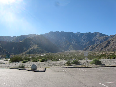


Looking west from the Tramway Gas Station parking lot toward the San Jacinto Mountains.  The road in the distance leads to the tramway.

These last photos are of Denis and Rob's home, a 1966 midcentury beauty in the Alexander tract.  The ethereal moonlight night shot was taken by Rob - thanks!